


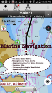
i-Boating
Marine Navigation

Описание на i-Boating: Marine Navigation
Това приложение за морски карти предлага офлайн морски карти, навигационни карти за вътрешни реки и контурни карти на езера за риболов, каяк, яхтинг и ветроходство.
Първото приложение за морска навигация, което има помощ за маршрута на лодка с гласови подкани. Всички функции на плотер за морски карти в едно приложение!
Поддържа ориентация на курса на морските карти нагоре. Включва графики на приливите и теченията за навигационна навигация.
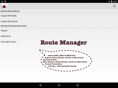
Създайте нови маршрути за лодка/пътни точки или импортирайте съществуващи GPX/KML маршрути на устройството. Има поддръжка за морски AIS (NMEA).
►ХАРАКТЕРИСТИКИ
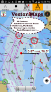
√ GPU ускорени офлайн векторни NOAA диаграми/ENC диаграми (текстът остава изправен при завъртане)
√ Засенчване на картата на дълбочината на езерото/безопасни контури на дълбочината на езерото: персонализирана безопасна дълбочина на лодката
√ Морски средства за навигация на лодки: маяци, шамандури, зони за излитане на лодки, рампи за лодки, яхтено пристанище, риболовни атракциони
√ Записвайте морски следи, автоматично следване с наслагване на следи в реално време
√ Гласови подкани за морска навигация
√ HD езерни контурни карти с дълбочина 1 фут/3 фута за риболовци за избрани езерни карти: за риболов/тролинг (сладководни/соленоводни).
√ GPX/KML за маршрут с лодка.
√ Безпроблемно изписване на морски карти: Подробности от крайбрежни, подходи, пристанищни и вътрешни ENC (електронни морски карти)
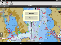
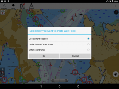
√ Точки
√ Приливи и течения.
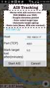
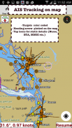
√ Морски AIS
√ Anchor Аларма
√ Увеличаване на текст и икони
√ Наслагване за прогнозиране на вятъра
√ Истински/магнитен лагер
► AI за горещи точки за риболов
► Температурни карти на езерото (термоклин с точност до 1°F (0,5°C)
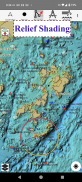
► Релефно засенчване
► КАРТИ
Всички детайли на морските картографи!
Неограничени актуализации за 1 година.
САЩ: Карти, включително покритие на морски карти на NOAA, ENC, карти на вътрешни реки на USACE и батиметрични карти на сладководни езера за повече от 50K езера. Графики, включително HD/1 фут батиметрия за избрани езера. Включва морски карти (растери) на NOAA с покритие на NOAA ENC.
Канада: Данни на CHS, включително Големите езера (от страната на САЩ и Канада), езерата на Алберта и Онтарио, езерото Симко и канала Трент Северн, резервоарите на Квебек.
Обединеното кралство/Ирландия: морски карти UKHO
Германия: BSH карти, водни пътища и реки.
Франция
Европа Вътрешни реки: Дунав/Дунав/Дуная, Рейн, Рейн, Гарона, Мозел, Драва, Сава
Австралия
Холандия/Холандия
Хърватия
Финландия
Норвегия
Швеция
Бразилия
Испания
Малта, Кипарис, Средиземно море
Карибите
Нова Зеландия
Дания, Гренландия, Фарьорски острови
Сейшели, Мавриций, Танзания
Фолклендски острови
Малайзия, Южнокитайско море
Персийски/Арабски залив, Червено море
Южна Африка
Аржентина
Исландия
Фиджи
Естония, Латвия, Полша, Литва
Турция, Гърция, Италия
►Инструментариум
√ Морски AIS & (NMEA AIS и GPS - TCP/UDP)
√ Посока и скорост на вятъра, дълбочина на морски сонар, температура на водата
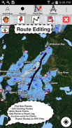
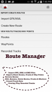
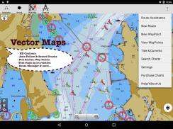
►УПРАВЛЕНИЕ НА МАРШРУТА/ПЛАНИРАНЕ НА ПЪТУВАНЕТО
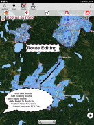
√ Създаване/Редактиране/Обръщане на маршрути за лодка
√ Управление на пътни точки
√ Импортирайте GPX, KML и KMZ файлове
√ Споделяне/експортиране на маршрути, дневник за плаване с лодка, следи и маркери
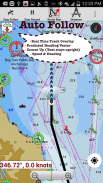
►ФУНКЦИИ за НАВИГАЦИЯ НА ЛОДКА
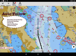
√ Автоматично следване
* Наслагване в реално време и вектор с прогнозиран път
* Курс нагоре
* Скорост и посока
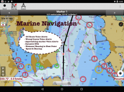
√ Помощ при насочване с гласови указания
* приближаващ маркер за маршрут с лодка
* Морско разстояние в реално време и ETA
* плаване/плаване с лодка извън маршрута/грешна посока
√ Запис на песни
►ПРИЛИВИ И ТЕЧЕНИЯ
* Приливи и отливи
* Прогноза за приливни течения
►морско време
*GFS + ECMWF
► СПОДЕЛЯНЕ
* Следи/Маршрути с лодки/маркери/Точки
* Експортиране на GPX.
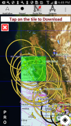
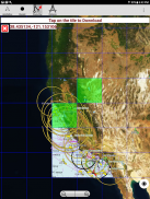
► Сателитни изображения
► Морски карти на САЩ
* Тексаски езера: Texoma, Eufaula, Toledo Bend
*Калифорнийски езера: Тахо, Шаста
Пенсилвански езера: Рейстаун
Флоридски езера: Окичоби, Кисими
* Езера Минесота: Минетонка, Уакония, Лич, Мил Лакс
* Масачузетски езера Куабин
* Езерата на Мисури: Труман
*Карти на езерото Охайо езеро Хувър
*Езера Уисконсин: Winnebago, Pepin
* Юта Лейк Пауъл, Беър
* Езерото Себаго в Мейн
*Аляска езера: Winnipesaukee
* Тенеси Лейк Баркли, Норис, Бар Уотс
* Южна Каролина Lake Keowee, Хартуел, Мъри
* Езерото Мичиган, Хурон, Онтарио, Горно, Ери
►Карти на езерата в Канада
* Lac Saint Jean
*Карти на дълбочината на езерото Онтарио
*Канал Ридо-река Отава
* Морски карти на Британска Колумбия
*Тихоокеанско крайбрежие-Ванкувър-Хайда Гуаи
*Нова Скотия Южен залив на Фънди
*Остров Квебек-Антикости
*Нюфаундленд
*Св. река Лорънс
*Манитоба и Саскачеван
*Грузински залив
* Пюджет Саунд
►Морски карти на Обединеното кралство
*Шотландия
*Устието на Темза
*Ирландия
►Австралийски морски и езерни карти
*Нов Южен Уелс
*Куинсланд
i-Boating:Marine Navigation - Version 259.0
(04-02-2025)
i-Boating: Marine Navigation - APK информация
APK версия: 259.0Пакет: com.skiracer.nautical_astore_liteLatest Version of i-Boating:Marine Navigation
Други версии


Apps in the same category


